
Thank you for supporting this site ❤️
Make a donation
Make a donation
Girod topographic map
Click on the map to display elevation.
Thank you for supporting this site ❤️
Make a donation
Make a donation
About this map
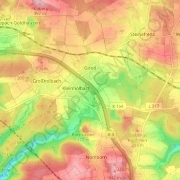
Name: Girod topographic map, elevation, terrain.
Location: Girod, Montabaur, Westerwaldkreis, Rijnland-Palts, Duitsland (50.42179 7.86874 50.46827 7.94041)
Average elevation: 280 m
Minimum elevation: 182 m
Maximum elevation: 352 m
Thank you for supporting this site ❤️
Make a donation
Make a donation