
Thank you for supporting this site ❤️
Make a donation
Make a donation
Mamoudzou topographic map
Click on the map to display elevation.
Thank you for supporting this site ❤️
Make a donation
Make a donation
About this map
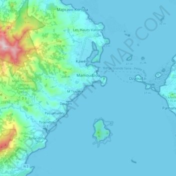
Name: Mamoudzou topographic map, elevation, terrain.
Location: Mamoudzou, Mayotte, France (-12.82228 45.15255 -12.75271 45.25116)
Average elevation: 59 m
Minimum elevation: -1 m
Maximum elevation: 550 m
Thank you for supporting this site ❤️
Make a donation
Make a donation
Other topographic maps
Click on a map to view its topography, its elevation and its terrain.