
Thank you for supporting this site ❤️
Make a donation
Make a donation
Hammond topographic map
Click on the map to display elevation.
Thank you for supporting this site ❤️
Make a donation
Make a donation
About this map
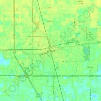
Name: Hammond topographic map, elevation, terrain.
Location: Hammond, Tangipahoa Parish, Louisiana, United States (30.46292 -90.51674 30.54629 -90.39829)
Average elevation: 13 m
Minimum elevation: 3 m
Maximum elevation: 20 m
Thank you for supporting this site ❤️
Make a donation
Make a donation
Other topographic maps
Click on a map to view its topography, its elevation and its terrain.
Thank you for supporting this site ❤️
Make a donation
Make a donation
Ponchatoula
United States > Louisiana > Tangipahoa Parish > Ponchatoula > Ponchatoula
Ponchatoula is located at 30°26′21″N 90°26′33″W / 30.43917°N 90.44250°W / 30.43917; -90.44250 (30.439162, -90.442507) and has an elevation of 26 feet (7.9 m). According to the United States Census Bureau, the city has a total area of 4.2 square miles (11 km2), all land.
Average elevation: 7 m