
Thank you for supporting this site ❤️
Make a donation
Make a donation
Alès topographic map
Click on the map to display elevation.
Thank you for supporting this site ❤️
Make a donation
Make a donation
About this map
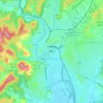
Name: Alès topographic map, elevation, terrain.
Location: Alès, Gard, Occitania, Metropolitan France, 30100, France (44.09368 4.05354 44.15635 4.12761)
Average elevation: 169 m
Minimum elevation: 114 m
Maximum elevation: 350 m
Thank you for supporting this site ❤️
Make a donation
Make a donation
Other topographic maps
Click on a map to view its topography, its elevation and its terrain.
Thank you for supporting this site ❤️
Make a donation
Make a donation
Thank you for supporting this site ❤️
Make a donation
Make a donation
Thank you for supporting this site ❤️
Make a donation
Make a donation