
Thank you for supporting this site ❤️
Make a donation
Make a donation
Logan County topographic map
Click on the map to display elevation.
Thank you for supporting this site ❤️
Make a donation
Make a donation
About this map
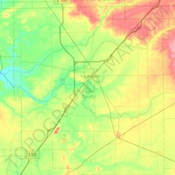
Name: Logan County topographic map, elevation, terrain.
Location: Logan County, Illinois, United States (39.91697 -89.60368 40.32529 -89.14346)
Average elevation: 184 m
Minimum elevation: 154 m
Maximum elevation: 238 m
Thank you for supporting this site ❤️
Make a donation
Make a donation
Other topographic maps
Click on a map to view its topography, its elevation and its terrain.
Sturbridge Village
United States > Illinois > Winnebago County > Sturbridge Village
Average elevation: 230 m
Thank you for supporting this site ❤️
Make a donation
Make a donation