
Tombebœuf topographic map
Interactive map
Click on the map to display elevation.
About this map
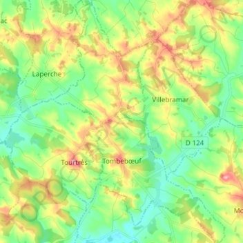
Name: Tombebœuf topographic map, elevation, terrain.
Average elevation: 98 m
Minimum elevation: 53 m
Maximum elevation: 172 m
Other topographic maps
Click on a map to view its topography, its elevation and its terrain.
Castelnaud-de-Gratecambe
France > Nouvelle-Aquitaine > Lot-et-Garonne
Castelnaud-de-Gratecambe, Villeneuve-sur-Lot, Lot-et-Garonne, Nouvelle-Aquitaine, Metropolitan France, 47290, France
Average elevation: 146 m
47290
France > Nouvelle-Aquitaine > Lot-et-Garonne > Moulinet
47290, Rouchou-Bas, Moulinet, Villeneuve-sur-Lot, Lot-et-Garonne, Nouvelle-Aquitaine, Metropolitan France, France
Average elevation: 113 m
Tournon-d'Agenais
France > Nouvelle-Aquitaine > Lot-et-Garonne
Tournon-d'Agenais, Villeneuve-sur-Lot, Lot-et-Garonne, Nouvelle-Aquitaine, Metropolitan France, 47370, France
Average elevation: 184 m
Fals
France > Nouvelle-Aquitaine > Lot-et-Garonne
Fals, Agen, Lot-et-Garonne, Nouvelle-Aquitaine, Metropolitan France, 47220, France
Average elevation: 96 m
Foulayronnes
France > Nouvelle-Aquitaine > Lot-et-Garonne
Foulayronnes, Agen, Lot-et-Garonne, Nouvelle-Aquitaine, Metropolitan France, 47510, France
Average elevation: 146 m
Feugarolles
France > Nouvelle-Aquitaine > Lot-et-Garonne
Feugarolles, Nérac, Lot-et-Garonne, Nouvelle-Aquitaine, Metropolitan France, 47230, France
Average elevation: 79 m
Nicole
France > Nouvelle-Aquitaine > Lot-et-Garonne
Nicole, Agen, Lot-et-Garonne, Nouvelle-Aquitaine, Metropolitan France, 47190, France
Average elevation: 62 m
Saint-Salvy
France > Nouvelle-Aquitaine > Lot-et-Garonne
Saint-Salvy, Agen, Lot-et-Garonne, Nouvelle-Aquitaine, Metropolitan France, 47360, France
Average elevation: 115 m
Monclar
France > Nouvelle-Aquitaine > Lot-et-Garonne
Monclar, Villeneuve-sur-Lot, Lot-et-Garonne, Nouvelle-Aquitaine, Metropolitan France, 47380, France
Average elevation: 98 m
Sainte-Bazeille
France > Nouvelle-Aquitaine > Lot-et-Garonne
Sainte-Bazeille, Marmande, Lot-et-Garonne, Nouvelle-Aquitaine, Metropolitan France, 47180, France
Average elevation: 28 m
Darel
France > Nouvelle-Aquitaine > Lot-et-Garonne > Pont-du-Casse
Darel, Pont-du-Casse, Agen, Lot-et-Garonne, Nouvelle-Aquitaine, Metropolitan France, 47480, France
Average elevation: 122 m
Saint-Étienne-de-Fougères
France > Nouvelle-Aquitaine > Lot-et-Garonne
Saint-Étienne-de-Fougères, Villeneuve-sur-Lot, Lot-et-Garonne, Nouvelle-Aquitaine, Metropolitan France, 47380, France
Average elevation: 54 m
Sainte-Livrade-sur-Lot
France > Nouvelle-Aquitaine > Lot-et-Garonne
Sainte-Livrade-sur-Lot, Villeneuve-sur-Lot, Lot-et-Garonne, Nouvelle-Aquitaine, Metropolitan France, 47110, France
Average elevation: 72 m
Blanquefort-sur-Briolance
France > Nouvelle-Aquitaine > Lot-et-Garonne
Blanquefort-sur-Briolance, Villeneuve-sur-Lot, Lot-et-Garonne, Nouvelle-Aquitaine, Metropolitan France, 47500, France
Average elevation: 214 m
Mauvezin-sur-Gupie
France > Nouvelle-Aquitaine > Lot-et-Garonne
Mauvezin-sur-Gupie, Marmande, Lot-et-Garonne, Nouvelle-Aquitaine, Metropolitan France, 47200, France
Average elevation: 75 m
Villeneuve-sur-Lot
France > Nouvelle-Aquitaine > Lot-et-Garonne
Villeneuve-sur-Lot, Lot-et-Garonne, Nouvelle-Aquitaine, Metropolitan France, 47300, France
Average elevation: 99 m
Grateloup-Saint-Gayrand
France > Nouvelle-Aquitaine > Lot-et-Garonne
Grateloup-Saint-Gayrand, Marmande, Lot-et-Garonne, Nouvelle-Aquitaine, Metropolitan France, 47400, France
Average elevation: 89 m
Villeréal
France > Nouvelle-Aquitaine > Lot-et-Garonne > Villeréal
Villeréal, Villeneuve-sur-Lot, Lot-et-Garonne, Nouvelle-Aquitaine, Metropolitan France, 47210, France
Average elevation: 109 m
Armillac
France > Nouvelle-Aquitaine > Lot-et-Garonne > Armillac
Armillac, Marmande, Lot-et-Garonne, Nouvelle-Aquitaine, Metropolitan France, 47800, France
Average elevation: 96 m
Astaffort
France > Nouvelle-Aquitaine > Lot-et-Garonne > Astaffort
Astaffort, Agen, Lot-et-Garonne, Nouvelle-Aquitaine, Metropolitan France, 47220, France
Average elevation: 115 m
Cambes
France > Nouvelle-Aquitaine > Lot-et-Garonne > Cambes
Cambes, Marmande, Lot-et-Garonne, Nouvelle-Aquitaine, Metropolitan France, 47350, France
Average elevation: 82 m
Clau de Lagleyse
France > Nouvelle-Aquitaine > Lot-et-Garonne > Thézac
Clau de Lagleyse, Thézac, Villeneuve-sur-Lot, Lot-et-Garonne, Nouvelle-Aquitaine, Metropolitan France, 47370, France
Average elevation: 202 m
Allez-et-Cazeneuve
France > Nouvelle-Aquitaine > Lot-et-Garonne
Allez-et-Cazeneuve, Villeneuve-sur-Lot, Lot-et-Garonne, Nouvelle-Aquitaine, Metropolitan France, 47110, France
Average elevation: 121 m
Barbaste
France > Nouvelle-Aquitaine > Lot-et-Garonne > Barbaste
Barbaste, Nérac, Lot-et-Garonne, Nouvelle-Aquitaine, Metropolitan France, 47230, France
Average elevation: 99 m
Duras
France > Nouvelle-Aquitaine > Lot-et-Garonne
Duras, Marmande, Lot-et-Garonne, Nouvelle-Aquitaine, Metropolitan France, 47120, France
Average elevation: 58 m
Lacépède
France > Nouvelle-Aquitaine > Lot-et-Garonne
Lacépède, Agen, Lot-et-Garonne, Nouvelle-Aquitaine, Metropolitan France, 47360, France
Average elevation: 107 m