
Thank you for supporting this site ❤️
Make a donation
Make a donation
Zaječice topographic map
Click on the map to display elevation.
Thank you for supporting this site ❤️
Make a donation
Make a donation
About this map
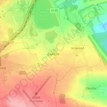
Name: Zaječice topographic map, elevation, terrain.
Average elevation: 302 m
Minimum elevation: 240 m
Maximum elevation: 354 m
Thank you for supporting this site ❤️
Make a donation
Make a donation
Other topographic maps
Click on a map to view its topography, its elevation and its terrain.
Thank you for supporting this site ❤️
Make a donation
Make a donation
Thank you for supporting this site ❤️
Make a donation
Make a donation
okres Děčín
Czechia > Northwest > Ústí nad Labem Region
Děčín District borders Germany in the north. It includes the Šluknov Hook area, surrounded by Germany on three sides. The district is a hilly and above-average forested area with several valleys and canyons. The territory extends into four geomorphological mesoregions: Elbe Sandstone Mountains (northwest),…
Average elevation: 373 m
Thank you for supporting this site ❤️
Make a donation
Make a donation
Thank you for supporting this site ❤️
Make a donation
Make a donation