
Thank you for supporting this site ❤️
Make a donation
Make a donation
Ban Pha Mon topographic map
Click on the map to display elevation.
Thank you for supporting this site ❤️
Make a donation
Make a donation
About this map
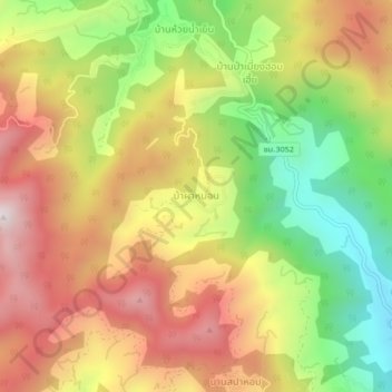
Name: Ban Pha Mon topographic map, elevation, terrain.
Location: Ban Pha Mon, Mae Taeng, Chiang Mai Province, Thailand (19.14472 98.78445 19.18472 98.82445)
Average elevation: 915 m
Minimum elevation: 488 m
Maximum elevation: 1,315 m
Thank you for supporting this site ❤️
Make a donation
Make a donation
Other topographic maps
Click on a map to view its topography, its elevation and its terrain.