
Thank you for supporting this site ❤️
Make a donation
Make a donation
Pígara topographic map
Click on the map to display elevation.
Thank you for supporting this site ❤️
Make a donation
Make a donation
About this map
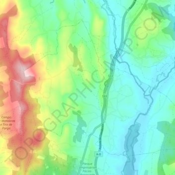
Name: Pígara topographic map, elevation, terrain.
Location: Pígara, Guitiriz, Tierra Chá, Lugo, Galicia, 27372, España (43.19185 -7.78688 43.24728 -7.68938)
Average elevation: 480 m
Minimum elevation: 393 m
Maximum elevation: 675 m
Thank you for supporting this site ❤️
Make a donation
Make a donation
Other topographic maps
Click on a map to view its topography, its elevation and its terrain.