
Thank you for supporting this site ❤️
Make a donation
Make a donation
Desenberg topographic map
Click on the map to display elevation.
Thank you for supporting this site ❤️
Make a donation
Make a donation
About this map
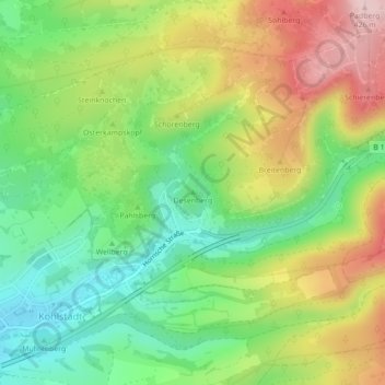
Name: Desenberg topographic map, elevation, terrain.
Average elevation: 299 m
Minimum elevation: 193 m
Maximum elevation: 444 m
Thank you for supporting this site ❤️
Make a donation
Make a donation
Other topographic maps
Click on a map to view its topography, its elevation and its terrain.
Oesterholz-Haustenbeck
Deutschland > Nordrhein-Westfalen > Kreis Lippe > Schlangen
Average elevation: 244 m