
Oral topographic map
Interactive map
Click on the map to display elevation.
About this map
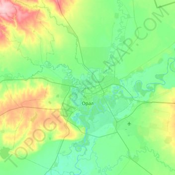
Name: Oral topographic map, elevation, terrain.
Location: Oral, West Kazakhstan Region, Kazakhstan (51.03227 51.21793 51.28641 51.51497)
Average elevation: 40 m
Minimum elevation: 18 m
Maximum elevation: 97 m
Other topographic maps
Click on a map to view its topography, its elevation and its terrain.
Караганды
Kazakhstan > West Kazakhstan Region > Syrym District > Шолақаңқаты ауылдық округі
Караганды, Шолақаңқаты ауылдық округі, Syrym District, West Kazakhstan Region, Kazakhstan
Average elevation: 41 m