Geolocate

Shining Tor topographic map

Click on the map to display elevation.

Shining Tor

Shining Tor is the highest hill in Cheshire, England. The summit has an elevation of 559 m (1,834 ft) above sea level. It is in the Peak District, between the towns of Macclesfield in Cheshire and Buxton in Derbyshire, and is on the administrative boundary between Derbyshire and Cheshire East. The hill is at the south end of a north-south moorland ridge, which also includes Cats Tor, 519 metres (1,703 ft) high. There is also another hill named Shining Tor, above Dovedale in Derbyshire, at grid reference SK145545.

Wikipedia (CC-BY-SA 3.0)

About this map

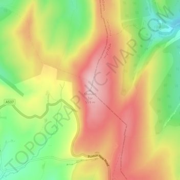
Name: Shining Tor topographic map, elevation, terrain.

Location: Shining Tor, Cheshire East, England, SK11 0AR, United Kingdom (53.26061 -2.00957 53.26071 -2.00947)

Average elevation: 440 m

Minimum elevation: 307 m

Maximum elevation: 559 m

Other topographic maps

Click on a map to view its topography, its elevation and its terrain.

Egerton

United Kingdom > England > Cheshire East

Average elevation: 104 m

Rode Pool

United Kingdom > England > Cheshire East > Rode Heath

Average elevation: 97 m

Congleton

United Kingdom > England > Cheshire East

Average elevation: 119 m

Pott Shrigley

United Kingdom > England > Cheshire East

Average elevation: 218 m

Ollerton

United Kingdom > England > Cheshire East

Average elevation: 66 m

Pott Shrigley

United Kingdom > England > Cheshire East

Average elevation: 218 m

Nantwich

United Kingdom > England > Cheshire East

Average elevation: 45 m

Spurstow

United Kingdom > England > Cheshire East > Bunbury

Average elevation: 87 m

Eaton

United Kingdom > England > Cheshire East > Eaton

Average elevation: 115 m

Oak Green

United Kingdom > England > Cheshire East > Wilmslow

Average elevation: 82 m

Tatton Park

United Kingdom > England > Cheshire East > Knutsford

Average elevation: 54 m

Knightslow Wood

United Kingdom > England > Cheshire East

Average elevation: 289 m

Knutsford

United Kingdom > England > Cheshire East

Average elevation: 57 m

Crewe

United Kingdom > England > Cheshire East

Average elevation: 52 m

Wincle

United Kingdom > England > Cheshire East

Average elevation: 270 m

Macclesfield

United Kingdom > England > Cheshire East

Average elevation: 182 m

Mobberley

United Kingdom > England > Cheshire East

Average elevation: 58 m

Worleston

United Kingdom > England > Cheshire East

Average elevation: 42 m

Congleton

United Kingdom > England > Cheshire East

Average elevation: 119 m

Macclesfield

United Kingdom > England > Cheshire East

Average elevation: 182 m

Bosley

United Kingdom > England > Cheshire East

Average elevation: 208 m

Handforth

United Kingdom > England > Cheshire East

Average elevation: 80 m

Wybunbury

United Kingdom > England > Cheshire East

Average elevation: 57 m

Knutsford

United Kingdom > England > Cheshire East

Average elevation: 57 m

Bunbury

United Kingdom > England > Cheshire East

Average elevation: 65 m

Congleton

United Kingdom > England > Cheshire East

Average elevation: 119 m

Sandbach

United Kingdom > England > Cheshire East

Average elevation: 64 m

Alsager

United Kingdom > England > Cheshire East

Average elevation: 96 m

Lyme Park

United Kingdom > England > Cheshire East > Disley

Average elevation: 260 m

Egerton

United Kingdom > England > Cheshire East

Average elevation: 104 m

Nantwich

United Kingdom > England > Cheshire East

Average elevation: 45 m

High Legh

United Kingdom > England > Cheshire East

Average elevation: 57 m

Crewe

United Kingdom > England > Cheshire East

Average elevation: 52 m

Haughton

United Kingdom > England > Cheshire East > Bunbury

Average elevation: 70 m

Brindley

United Kingdom > England > Cheshire East > Brindley

Average elevation: 81 m

Crewe

United Kingdom > England > Cheshire East

Average elevation: 52 m

Toft

United Kingdom > England > Cheshire East

Average elevation: 57 m

Buerton

United Kingdom > England > Cheshire East

Average elevation: 97 m

Arclid

United Kingdom > England > Cheshire East

Average elevation: 75 m

Cholmondeley

United Kingdom > England > Cheshire East

Average elevation: 94 m

Chelford

United Kingdom > England > Cheshire East

Average elevation: 78 m

Broomhall

United Kingdom > England > Cheshire East

Average elevation: 60 m

Wilmslow

United Kingdom > England > Cheshire East

Average elevation: 81 m

Disley

United Kingdom > England > Cheshire East

Average elevation: 229 m

Sandbach

United Kingdom > England > Cheshire East

Average elevation: 64 m

Alderley Edge

United Kingdom > England > Cheshire East

Alderley Edge is 6 miles (10 km) northwest of Macclesfield and 12 miles (19 km) south of Manchester, at the base of a steep and thickly wooded sandstone escarpment, Alderley Edge, which is the area's chief topographical feature and overlooks the Cheshire Plain.

Average elevation: 91 m

Knutsford

United Kingdom > England > Cheshire East

Average elevation: 57 m

Smallwood

United Kingdom > England > Cheshire East

Average elevation: 86 m

Chorley

United Kingdom > England > Cheshire East > Chorley

Average elevation: 73 m

Cranage

United Kingdom > England > Cheshire East

Average elevation: 52 m

Henbury

United Kingdom > England > Cheshire East > Henbury

Average elevation: 135 m

Prestbury

United Kingdom > England > Cheshire East

Average elevation: 130 m

Hankelow

United Kingdom > England > Cheshire East > Hankelow

Average elevation: 60 m

Rainow

United Kingdom > England > Cheshire East

Average elevation: 262 m

Alsager

United Kingdom > England > Cheshire East

Average elevation: 96 m

Bridgemere

United Kingdom > England > Cheshire East

Average elevation: 89 m

Macclesfield

United Kingdom > England > Cheshire East

Average elevation: 182 m

Goostrey

United Kingdom > England > Cheshire East

Average elevation: 67 m

Bollington

United Kingdom > England > Cheshire East

Average elevation: 163 m

Crewe

United Kingdom > England > Cheshire East

Average elevation: 52 m

Wistaston

United Kingdom > England > Cheshire East > Wistaston

Average elevation: 46 m

Middlewich

United Kingdom > England > Cheshire East

Average elevation: 40 m

Audlem

United Kingdom > England > Cheshire East > Audlem

Average elevation: 72 m

Ollerton

United Kingdom > England > Cheshire East

Average elevation: 66 m

Pickmere

United Kingdom > England > Cheshire East

Average elevation: 41 m

Walgherton

United Kingdom > England > Cheshire East > Wybunbury

Average elevation: 63 m

Bickerton

United Kingdom > England > Cheshire East

Average elevation: 128 m

Bosley

United Kingdom > England > Cheshire East

Average elevation: 208 m

Gawsworth

United Kingdom > England > Cheshire East

Average elevation: 145 m

Holmes Chapel

United Kingdom > England > Cheshire East

Average elevation: 58 m

Barthomley

United Kingdom > England > Cheshire East

Average elevation: 86 m

Weston

United Kingdom > England > Cheshire East

Average elevation: 69 m

Adlington

United Kingdom > England > Cheshire East

Average elevation: 124 m

Crewe

United Kingdom > England > Cheshire East

Average elevation: 52 m

Wilmslow

United Kingdom > England > Cheshire East

Average elevation: 81 m

Somerford

United Kingdom > England > Cheshire East

Average elevation: 82 m

Styal

United Kingdom > England > Cheshire East

Average elevation: 76 m

Haslington

United Kingdom > England > Cheshire East > Winterley

Average elevation: 64 m

Crewe

United Kingdom > England > Cheshire East

Average elevation: 52 m

Calveley

United Kingdom > England > Cheshire East

Average elevation: 51 m