
Make a donation
Molina de Aragón topographic map
Click on the map to display elevation.
Make a donation
Molina de Aragón
Molina de Aragón has a warm-summer mediterranean climate (Köppen climate classification: Csb) with some semi-arid influences. Precipitation is irregular throughout the year, with most rainfall occurring during spring and autumn. Winters are cold for Spanish standards, with temperatures often below 0 °C (32 °F) due to its altitude and its inland location. Summers are warm with mean maximum around 30 °C (86 °F) while the nights remain relatively cool.
Make a donation
About this map
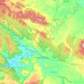
Name: Molina de Aragón topographic map, elevation, terrain.
Location: Molina de Aragón, Guadalajara, Castile-La Mancha, 19300, Spain (40.80252 -1.92884 40.94584 -1.70716)
Average elevation: 1,163 m
Minimum elevation: 1,012 m
Maximum elevation: 1,413 m
Make a donation
Other topographic maps
Click on a map to view its topography, its elevation and its terrain.
Make a donation
Make a donation
Make a donation
Make a donation
Make a donation
Make a donation
Make a donation
Make a donation
Make a donation
Make a donation