Paraná topographic map
Click on the map to display elevation.
Paraná
The state can be separated into five main topographic areas, from east to west: a coastal zone, the mountains of Serra do Mar, and then three plateaus, each lower than the other, until the Paraná River is reached.
About this map
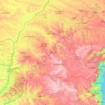
Name: Paraná topographic map, elevation, terrain.
Location: Paraná, South Region, Brazil (-26.72090 -54.61986 -22.51600 -47.85611)
Average elevation: 548 m
Minimum elevation: -1 m
Maximum elevation: 1,585 m
Other topographic maps
Click on a map to view its topography, its elevation and its terrain.
São Paulo
Brazil > São Paulo > Região Metropolitana de São Paulo > São Paulo
São Paulo is in Southeastern Brazil, in southeastern São Paulo State, approximately halfway between Curitiba and Rio de Janeiro. The city is on a plateau placed beyond the Serra do Mar (Portuguese for "Sea Range" or "Coastal Range"), itself a component of the vast region known as the Brazilian Highlands,…
Average elevation: 785 m
Serra da Mantiqueira
Brazil > São Paulo > Região Metropolitana do Vale do Paraíba e Litoral Norte > Queluz
The Serra da Mantiqueira is a part of the Atlantic Forest ecosystem. Despite the clearing of the land for livestock raising, the difficult access to many areas has made possible for sanctuaries of well-preserved forest to still exist, with trees such as the jacarandá, Spanish cedar, canjerana, guatambu, ipê,…
Average elevation: 2,271 m
Região Metropolitana do Recife
Brazil > Pernambuco > Região Metropolitana do Recife > Cabo de Santo Agostinho
Average elevation: 119 m


Amazon River
During what many archaeologists called the formative stage, Amazonian societies were deeply involved in the emergence of South America's highland agrarian systems. The trade with Andean civilizations in the terrains of the headwaters in the Andes formed an essential contribution to the social and religious…
Average elevation: 11 m




Belo Horizonte
Brazil > Minas Gerais > Região Metropolitana de Belo Horizonte > Belo Horizonte
In 1893, due to the climatic and topographic conditions, Curral Del Rey was selected by Minas Gerais governor Afonso Pena among other cities as the location for the new economic and cultural center of the state, under the new name of Cidade de Minas, or City of Minas.
Average elevation: 904 m


Atlantic Forest
Brazil > São Paulo > Região Metropolitana de São Paulo > Ribeirão Pires
Average elevation: 787 m