
Thank you for supporting this site ❤️
Make a donation
Make a donation
Kibworth Beauchamp topographic map
Click on the map to display elevation.
Thank you for supporting this site ❤️
Make a donation
Make a donation
About this map
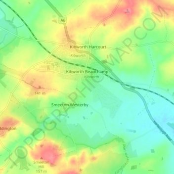
Name: Kibworth Beauchamp topographic map, elevation, terrain.
Average elevation: 113 m
Minimum elevation: 79 m
Maximum elevation: 163 m
Thank you for supporting this site ❤️
Make a donation
Make a donation
Other topographic maps
Click on a map to view its topography, its elevation and its terrain.
Thank you for supporting this site ❤️
Make a donation
Make a donation
Adrian's Spinney
United Kingdom > England > Leicestershire > Harborough > Stoughton
Average elevation: 113 m
Thank you for supporting this site ❤️
Make a donation
Make a donation
Thank you for supporting this site ❤️
Make a donation
Make a donation
Thank you for supporting this site ❤️
Make a donation
Make a donation
Thank you for supporting this site ❤️
Make a donation
Make a donation
Thank you for supporting this site ❤️
Make a donation
Make a donation
Saddington Reservoir
United Kingdom > England > Leicestershire > Harborough > Saddington
Average elevation: 128 m
Thank you for supporting this site ❤️
Make a donation
Make a donation
Halstead
United Kingdom > England > Leicestershire > Harborough > Tilton on the Hill > Halstead
Average elevation: 179 m
Thank you for supporting this site ❤️
Make a donation
Make a donation
Thank you for supporting this site ❤️
Make a donation
Make a donation
Thank you for supporting this site ❤️
Make a donation
Make a donation