Mount McKinley topographic map
Interactive map
Click on the map to display elevation.
About this map
![Mount McKinley topographic map, elevation, terrain](/pub/maps/node/mhz4/cbxrdb3/thumbnail.jpg)
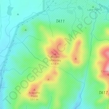
Name: Mount McKinley topographic map, elevation, terrain.
Location: Mount McKinley, Comanche County, Oklahoma, United States (34.69474 -98.61178 34.69484 -98.61168)
Average elevation: 498 m
Minimum elevation: 429 m
Maximum elevation: 652 m
Other topographic maps
Click on a map to view its topography, its elevation and its terrain.
![Academic Hights topographic map, elevation, terrain](/pub/maps/way/32rr/mtl23cz4/icon.jpg)
Academic Hights
United States > Oklahoma > Comanche County > Lawton
Academic Hights, Lawton, Comanche County, Oklahoma, United States
Average elevation: 348 m
![Jackson Hole topographic map, elevation, terrain](/pub/maps/way/6fz4/w7qq9jnx/icon.jpg)
Jackson Hole
United States > Oklahoma > Comanche County
Jackson Hole, Comanche County, Oklahoma, United States
Average elevation: 406 m
![Lawton topographic map, elevation, terrain](/pub/maps/relation/68b3/vljtj/icon.jpg)
Lawton
United States > Oklahoma > Comanche County
Lawton, Comanche County, Oklahoma, United States
Average elevation: 352 m
![Meers topographic map, elevation, terrain](/pub/maps/node/d8s8/n4nvh3q/icon.jpg)
Meers
United States > Oklahoma > Comanche County
Meers, Comanche County, Oklahoma, United States
Average elevation: 457 m
![Lake Lawtonka topographic map, elevation, terrain](/pub/maps/way/hhtj/6nkx11h/icon.jpg)
Lake Lawtonka
United States > Oklahoma > Comanche County
Lake Lawtonka, Comanche County, Oklahoma, United States
Average elevation: 428 m
![Fort Sill topographic map, elevation, terrain](/pub/maps/relation/7xzs/21sb3q/icon.jpg)
Fort Sill
United States > Oklahoma > Comanche County
Fort Sill, Comanche County, Oklahoma, United States
Average elevation: 417 m
![Indiahoma topographic map, elevation, terrain](/pub/maps/relation/j9nx/6qm9m/icon.jpg)
Indiahoma
United States > Oklahoma > Comanche County
Indiahoma, Comanche County, Oklahoma, United States
Average elevation: 405 m
![Geronimo topographic map, elevation, terrain](/pub/maps/relation/1j3q/3wndn/icon.jpg)
Geronimo
United States > Oklahoma > Comanche County
Geronimo, Comanche County, Oklahoma, 73543, United States
Average elevation: 328 m
![Chattanooga topographic map, elevation, terrain](/pub/maps/relation/wdt6/9rszs/icon.jpg)
Chattanooga
United States > Oklahoma > Comanche County
Chattanooga, Comanche County, Oklahoma, 73528, United States
Average elevation: 347 m
![Cache topographic map, elevation, terrain](/pub/maps/relation/lhz4/lbpgp/icon.jpg)
Cache
United States > Oklahoma > Comanche County
Cache, Comanche County, Oklahoma, 73527, United States
Average elevation: 386 m
![Faxon topographic map, elevation, terrain](/pub/maps/relation/3tgp/z4xnx/icon.jpg)
Faxon
United States > Oklahoma > Comanche County
Faxon, Comanche County, Oklahoma, United States
Average elevation: 334 m
![Sterling topographic map, elevation, terrain](/pub/maps/relation/f49m/5t757/icon.jpg)
Sterling
United States > Oklahoma > Comanche County
Sterling, Comanche County, Oklahoma, 73567, United States
Average elevation: 372 m
![Fletcher topographic map, elevation, terrain](/pub/maps/relation/73zs/kc3b3/icon.jpg)
Fletcher
United States > Oklahoma > Comanche County
Fletcher, Comanche County, Oklahoma, United States
Average elevation: 417 m
![Elk Mountain topographic map, elevation, terrain](/pub/maps/node/25rr/cb9t7f3/icon.jpg)
Elk Mountain
United States > Oklahoma > Comanche County
Elk Mountain, Comanche County, Oklahoma, United States
Average elevation: 543 m
![Elgin topographic map, elevation, terrain](/pub/maps/relation/8ngt/nfq3q/icon.jpg)
Elgin
United States > Oklahoma > Comanche County
Elgin, Comanche County, Oklahoma, United States
Average elevation: 393 m
![Pratt Hill topographic map, elevation, terrain](/pub/maps/node/99t6/bkdl7gp/icon.jpg)
Pratt Hill
United States > Oklahoma > Comanche County
Pratt Hill, Comanche County, Oklahoma, 73557, United States
Average elevation: 442 m
![Lawton topographic map, elevation, terrain](/pub/maps/node/p1tj/z1bc8nx/icon.jpg)
Lawton
United States > Oklahoma > Comanche County > Lawton
Lawton, Comanche County, Oklahoma, 73501, United States
Average elevation: 361 m
![Cove Acres topographic map, elevation, terrain](/pub/maps/node/3ktp/7wckt18/icon.jpg)
Cove Acres
United States > Oklahoma > Comanche County > Cove Acres
Cove Acres, Comanche County, Oklahoma, 73006, United States
Average elevation: 381 m
![Cross Mountain topographic map, elevation, terrain](/pub/maps/node/mxcz/l4n7vtj/icon.jpg)
Cross Mountain
United States > Oklahoma > Comanche County
Cross Mountain, Comanche County, Oklahoma, United States
Average elevation: 530 m
![Medicine Park topographic map, elevation, terrain](/pub/maps/relation/mvdn/4k2m2/icon.jpg)
Medicine Park
United States > Oklahoma > Comanche County
Medicine Park, Comanche County, Oklahoma, 73557, United States
Average elevation: 429 m