
Thank you for supporting this site ❤️
Make a donation
Make a donation
Carpaneto topographic map
Click on the map to display elevation.
Thank you for supporting this site ❤️
Make a donation
Make a donation
About this map
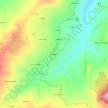
Name: Carpaneto topographic map, elevation, terrain.
Average elevation: 634 m
Minimum elevation: 412 m
Maximum elevation: 966 m
Thank you for supporting this site ❤️
Make a donation
Make a donation
Other topographic maps
Click on a map to view its topography, its elevation and its terrain.
Castello di Tizzano Val Parma
Italia > Emilia-Romagna > Parma > Tizzano Val Parma > Gubinaria
Average elevation: 706 m