
Make a donation
Bolikhamsai topographic map
Click on the map to display elevation.
Make a donation
Bolikhamsai
Bolikhamsai province has a rugged terrain, with large boulders and streams. Its elevation ranges from 140–1,588 metres (459–5,210 ft). The principal river is the Nam Kading, meaning 'water like a bell', a tributary of the Mekong; its catchment covers about 92% of the provincial area. The other main rivers are the Nam Muan, Nam Sat, and the Nam Tek. Waterfalls of note include the Tad Leuk, Tad Xay and Tad Xang. The longest mountain range in the province is the Phou Louang range, running to the southwest, the Phou Ao range to the southeast; the Thalabat range to the northwest, and the Pa Guang range to the northeast. In Khamkheuth District, there is karst limestone scenery, which is allegedly the largest formation of its type in Southeast Asia. The many rock pinnacles have formed stone forest similar to limestone outcrops in southern China.
Make a donation
About this map
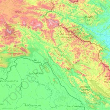
Name: Bolikhamsai topographic map, elevation, terrain.
Location: Bolikhamsai, Laos (17.86978 102.81023 19.12116 105.25881)
Average elevation: 528 m
Minimum elevation: 7 m
Maximum elevation: 2,779 m
Make a donation
Other topographic maps
Click on a map to view its topography, its elevation and its terrain.
Make a donation
Make a donation
Make a donation
Make a donation
Make a donation
Make a donation
B. Haysok
Laos > Vientiane Prefecture > Chanthabuly District > Vientiane Capital
Average elevation: 170 m
Make a donation
Saphangmo
Laos > Vientiane Prefecture > Xaysetha District > Vientiane Capital
Average elevation: 170 m
Make a donation
Donnokkhoum
Laos > Vientiane Prefecture > Sisattanak District > Vientiane Capital
Average elevation: 170 m
Phonsinouan
Laos > Vientiane Prefecture > Sisattanak District > Vientiane Capital
Average elevation: 170 m
Make a donation
Nongtaeng
Laos > Vientiane Prefecture > Sikhottabong District > Vientiane Capital
Average elevation: 174 m
Make a donation
Dongkhamxang
Laos > Vientiane Prefecture > Hadxayfong District > Vientiane Capital
Average elevation: 172 m
Nonghai
Laos > Vientiane Prefecture > Hadxayfong District > Vientiane Capital
Average elevation: 172 m
Make a donation
Muangvatha
Laos > Vientiane Prefecture > Sikhottabong District > Vientiane Capital
Average elevation: 169 m
Dognaxoyneua
Laos > Vientiane Prefecture > Sikhottabong District > Vientiane Capital
Average elevation: 169 m
Make a donation
ທົ່ງປົງ
Laos > Vientiane Prefecture > Sikhottabong District > Vientiane Capital
Average elevation: 174 m
Nongtha Marsh
Laos > Vientiane Prefecture > Chanthabuly District > Vientiane Capital > B. Nongthanua
Average elevation: 175 m
Make a donation
Don Koy
Laos > Vientiane Prefecture > Sisattanak District > Vientiane Capital
Average elevation: 169 m
Chommanytai
Laos > Vientiane Prefecture > Xaysetha District > Vientiane Capital
Average elevation: 172 m
Make a donation
Make a donation
Make a donation
Dongphosy
Laos > Vientiane Prefecture > Hadxayfong District > Vientiane Capital
Average elevation: 168 m
Make a donation
Thatlouangkang
Laos > Vientiane Prefecture > Xaysetha District > Vientiane Capital
Average elevation: 170 m
Make a donation
Make a donation
Make a donation
Make a donation
Make a donation
Sibounheuang
Laos > Vientiane Prefecture > Chanthabuly District > Sibounheuang
Average elevation: 171 m
Make a donation
Xiangkhouang
Xiangkhouang province covers an area of 15,880 square kilometres (6,130 sq mi) and is mountainous. Apart from floodplains, the largest area of level land in the country is on the province's Xiangkhoang Plateau. The plateau is characterized by rolling hills and grassland whose elevation averages 1,300 metres…
Average elevation: 565 m
Make a donation
Make a donation