
Pfalzel topographic map
Interactive map
Click on the map to display elevation.
About this map
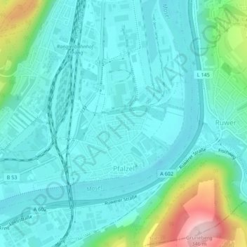
Name: Pfalzel topographic map, elevation, terrain.
Location: Pfalzel, Trèves, Rhénanie-Palatinat, Allemagne (49.77708 6.67647 49.79320 6.70447)
Average elevation: 159 m
Minimum elevation: 114 m
Maximum elevation: 345 m
Other topographic maps
Click on a map to view its topography, its elevation and its terrain.
Trèves
Allemagne > Rhénanie-Palatinat > Trèves
Trèves, Trier, Rhénanie-Palatinat, 54290, Allemagne
Average elevation: 314 m
Ehrang
Allemagne > Rhénanie-Palatinat > Trèves
Ehrang, Ehrang-Quint, Trèves, Rhénanie-Palatinat, 54293, Allemagne
Average elevation: 226 m