
Thank you for supporting this site ❤️
Make a donation
Make a donation
Hamminkeln topographic map
Click on the map to display elevation.
Thank you for supporting this site ❤️
Make a donation
Make a donation
About this map
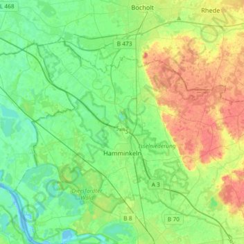
Name: Hamminkeln topographic map, elevation, terrain.
Location: Hamminkeln, Kreis Wesel, Nordrhein-Westfalen, 46499, Deutschland (51.69070 6.48208 51.81657 6.77285)
Average elevation: 27 m
Minimum elevation: 10 m
Maximum elevation: 58 m
Thank you for supporting this site ❤️
Make a donation
Make a donation
Other topographic maps
Click on a map to view its topography, its elevation and its terrain.
Krudenburg
Deutschland > Nordrhein-Westfalen > Kreis Wesel
Maximilianpark | Schulweg-Steg | Schleuse Werries | Lippeschleuse Heessen | Kurpark Hamm | Wasserübergabe Hamm | Schleuse Hamm | Klostermühle Pohl | Wassertürme am Hellweg | Bahnhof Hamm | Stadthafen Hamm | Zeche Sachsen heute Öko-Zentrum NRW | Siedlung Vogelsang | Zeche Radbod | Gedenkstätte Zeche Radbod…
Average elevation: 33 m
Thank you for supporting this site ❤️
Make a donation
Make a donation