
Thank you for supporting this site ❤️
Make a donation
Make a donation
Monte De Luz topographic map
Click on the map to display elevation.
Thank you for supporting this site ❤️
Make a donation
Make a donation
About this map
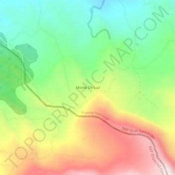
Name: Monte De Luz topographic map, elevation, terrain.
Location: Monte De Luz, Puente Nacional, Vélez, Santander, Colombia (5.74020 -73.70829 5.78020 -73.66829)
Average elevation: 2,738 m
Minimum elevation: 2,409 m
Maximum elevation: 3,186 m
Thank you for supporting this site ❤️
Make a donation
Make a donation
Other topographic maps
Click on a map to view its topography, its elevation and its terrain.