
Thank you for supporting this site ❤️
Make a donation
Make a donation
Dodawali topographic map
Click on the map to display elevation.
Thank you for supporting this site ❤️
Make a donation
Make a donation
About this map
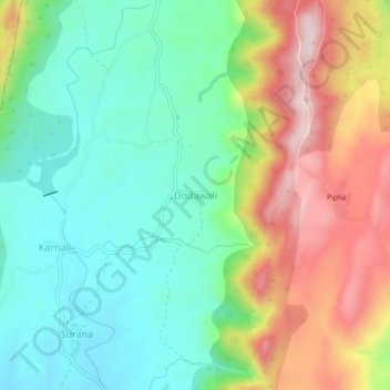
Name: Dodawali topographic map, elevation, terrain.
Location: Dodawali, Girwa Tehsil, Udaipur, Rajasthan, India (24.54283 73.52025 24.58283 73.56025)
Average elevation: 801 m
Minimum elevation: 646 m
Maximum elevation: 1,065 m
Thank you for supporting this site ❤️
Make a donation
Make a donation
Other topographic maps
Click on a map to view its topography, its elevation and its terrain.