
Thank you for supporting this site ❤️
Make a donation
Make a donation
Brønnøysund topographic map
Click on the map to display elevation.
Thank you for supporting this site ❤️
Make a donation
Make a donation
About this map
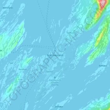
Name: Brønnøysund topographic map, elevation, terrain.
Location: Brønnøysund, Brønnøy, Nordland, 8900, Norway (65.43488 12.17164 65.51488 12.25164)
Average elevation: 8 m
Minimum elevation: -4 m
Maximum elevation: 320 m
Thank you for supporting this site ❤️
Make a donation
Make a donation
Other topographic maps
Click on a map to view its topography, its elevation and its terrain.
Thank you for supporting this site ❤️
Make a donation
Make a donation
Thank you for supporting this site ❤️
Make a donation
Make a donation