
Thank you for supporting this site ❤️
Make a donation
Make a donation
Tepoztlán topographic map
Click on the map to display elevation.
Thank you for supporting this site ❤️
Make a donation
Make a donation
About this map
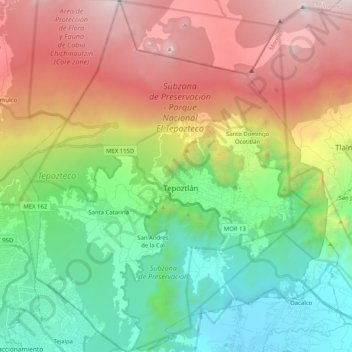
Name: Tepoztlán topographic map, elevation, terrain.
Location: Tepoztlán, Morelos, Mexico (18.89609 -99.19335 19.08930 -99.01456)
Average elevation: 2,098 m
Minimum elevation: 1,215 m
Maximum elevation: 3,469 m
Thank you for supporting this site ❤️
Make a donation
Make a donation
Other topographic maps
Click on a map to view its topography, its elevation and its terrain.