
Thank you for supporting this site ❤️
Make a donation
Make a donation
L'Angle topographic map
Click on the map to display elevation.
Thank you for supporting this site ❤️
Make a donation
Make a donation
About this map
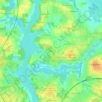
Name: L'Angle topographic map, elevation, terrain.
Average elevation: 16 m
Minimum elevation: 1 m
Maximum elevation: 36 m
Thank you for supporting this site ❤️
Make a donation
Make a donation
Other topographic maps
Click on a map to view its topography, its elevation and its terrain.
Réserve naturelle de la tourbière de Logné
France > Pays de la Loire > Loire-Atlantique > Carquefou
Average elevation: 11 m