
Tol topographic map
Interactive map
Click on the map to display elevation.
About this map
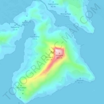
Name: Tol topographic map, elevation, terrain.
Location: Tol, Chuuk, Federated States of Micronesia (7.31858 151.60384 7.36208 151.63925)
Average elevation: 46 m
Minimum elevation: -3 m
Maximum elevation: 455 m
The highest point on Tol, Mount Winipot, is the highest point in Chuuk State, at an elevation of 448 meters (1,470 ft). The high jungle forest which surrounds this peak is the sole habitat of the endemic great Truk white-eye.