
Make a donation
Zamora Chinchipe topographic map
Click on the map to display elevation.
Make a donation
Zamora Chinchipe
Zamora Chinchipe (Spanish pronunciation: [saˈmoɾa tʃinˈtʃipe]), Province of Zamora Chinchipe is a province of the Republic of Ecuador, located at the southeastern end of the Amazon Basin, which shares borders with the Ecuadorian provinces of Azuay and Morona Santiago to the north, Loja and Azuay to the west, and with Peru to the east and south. The province comprises an area of approximately 10,559 km² and is covered with a uniquely mountainous topography which markedly distinguishes it from the surrounding Amazonian provinces. Zamora-Chinchipe is characterized and largely identified by its mining industry; indigenous ethnic groups with a rich archaeological legacy; its biodiversity; and its niche and tourist attractions, which include a number of waterfalls well-noted for their beauty. The province takes its name from the bureaucratic fusion of the Zamora and Chinchipe cantons. The provincial capital is the city of Zamora.
Make a donation
About this map
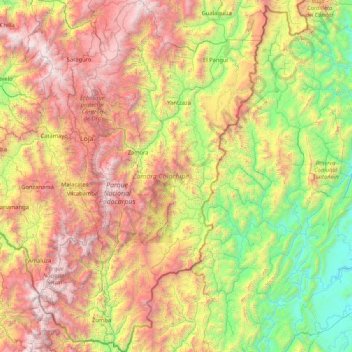
Name: Zamora Chinchipe topographic map, elevation, terrain.
Location: Zamora Chinchipe, Ecuador (-5.01593 -79.43060 -3.34187 -78.36765)
Average elevation: 1,548 m
Minimum elevation: 189 m
Maximum elevation: 3,911 m
Make a donation
Other topographic maps
Click on a map to view its topography, its elevation and its terrain.
Make a donation
Make a donation
Cordillera de la Bretaña
Ecuador > Sucumbíos > Sucumbíos > El Playón de San Francisco
Average elevation: 1,784 m
Make a donation
Make a donation
Make a donation
Laguna de Yambo
Ecuador > Cotopaxi > Salcedo > Patain > San Jose de Curiquingue
Average elevation: 2,664 m
Make a donation
Make a donation
Make a donation
Make a donation
Make a donation
Make a donation
Montañita
Ecuador > Santo Domingo de los Tsáchilas > Santo Domingo > Santo Domingo de los Tsachilas
Average elevation: 374 m
Make a donation
Sangay
Ecuador > Morona Santiago > Pablo Sexto > Pablo VI
Sangay is one of two active volcanoes in the Sangay National Park, the other being Tungurahua to the north. As such it has been listed as a UNESCO World Heritage Site since 1983. The area's isolation has allowed it to maintain a pristine ecology relatively untouched by human interaction, and the park hosts a…
Average elevation: 4,610 m
Volcán Cotopaxi
Ecuador > Pichincha > Machachi > Machachi
In the late 20th century, summiting Cotopaxi became a major tourist draw. The José F. Ribas Refuge (Refugio José Félix Ribas) was built in 1971 at an elevation of 4,864 m (15,960 ft) and enlarged in 2005.
Average elevation: 5,021 m
Make a donation
Make a donation
Make a donation
Inmortal Simón Bolívar
Ecuador > Sucumbíos > Nueva Loja > Inmortal Simón Bolívar
Average elevation: 300 m
San Jacinto de Buena Fe
Ecuador > Los Ríos > Buena Fe > San Jacinto de Buena Fe
Average elevation: 89 m
Make a donation
Make a donation
Puerto Francisco de Orellana
Ecuador > Orellana > Francisco de Orellana > Puerto Francisco de Orellana
Average elevation: 255 m
Make a donation
Make a donation
Cristo Rey
Ecuador > Santo Domingo de los Tsáchilas > La Concordia > La Villegas
Average elevation: 225 m
Make a donation
Make a donation
Make a donation