
Make a donation
Nueva Esparta State topographic map
Click on the map to display elevation.
Make a donation
Nueva Esparta State
Together, the three islands of the State bring together magnificent beaches, wonderful mangroves and other landscapes that make it a true island paradise. Margarita, the largest of them, has a maximum elevation on Copey Hill (900 meters above sea level) and includes the Macanao mountain core to the west. Coche and Cubagua are rocky cores covered with marine sediments and have a flat relief, with cliffs. The climate is arid or semi-arid, to the point that there are no permanent current rivers. The Nueva Esparta state is divided into 11 municipalities.
Make a donation
About this map
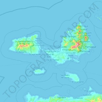
Name: Nueva Esparta State topographic map, elevation, terrain.
Location: Nueva Esparta State, Venezuela (10.69031 -64.46802 11.23857 -63.71767)
Average elevation: 15 m
Minimum elevation: -2 m
Maximum elevation: 890 m
Make a donation
Other topographic maps
Click on a map to view its topography, its elevation and its terrain.