
Thank you for supporting this site ❤️
Make a donation
Make a donation
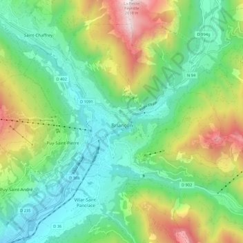
Briançon topographic map
Click on the map to display elevation.
Thank you for supporting this site ❤️
Make a donation
Make a donation
Briançon
Due to its elevation, Briançon features a warm-summer humid continental climate (Köppen : Dfb), bordering on an oceanic climate (Cfb) under the Köppen system. Summers are warm with cool nights, and winters are cold and snowy.
Thank you for supporting this site ❤️
Make a donation
Make a donation
About this map
Name: Briançon topographic map, elevation, terrain.
Average elevation: 1,614 m
Minimum elevation: 1,160 m
Maximum elevation: 2,597 m
Thank you for supporting this site ❤️
Make a donation
Make a donation