
Thank you for supporting this site ❤️
Make a donation
Make a donation
Oberwilzingen topographic map
Click on the map to display elevation.
Thank you for supporting this site ❤️
Make a donation
Make a donation
Oberwilzingen
Das Dorf liegt südöstlich von Hayingen auf einer Hochfläche der Schwäbischen Alb über dem Tal der Großen Lauter auf 595 Meter Meereshöhe.
Thank you for supporting this site ❤️
Make a donation
Make a donation
About this map
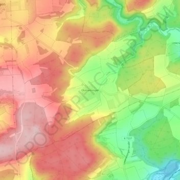
Name: Oberwilzingen topographic map, elevation, terrain.
Average elevation: 637 m
Minimum elevation: 509 m
Maximum elevation: 730 m
Thank you for supporting this site ❤️
Make a donation
Make a donation
Other topographic maps
Click on a map to view its topography, its elevation and its terrain.