
Make a donation
Moravian-Silesian Region topographic map
Click on the map to display elevation.
Make a donation
Moravian-Silesian Region
The Jeseníky PLA (with an area of 745 km2 or 288 sq mi) lies in the mountain range of the same name in the north east of the region. The terrain is very diverse, with steep slopes and deep valleys. About 80%t of the area is forested, mostly by secondary plantations of Norway spruce, which were seriously damaged by industrial emissions. Due to local weather conditions, the tree line in the area descends to 1,200–1,300 m (3,900–4,300 ft). Alpine meadows can be found in particularly low elevations in the Jeseník mountains. Also, a few peat moors are found there, which are otherwise nonexistent in Moravia.
Make a donation
About this map
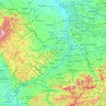
Name: Moravian-Silesian Region topographic map, elevation, terrain.
Location: Moravian-Silesian Region, Moravia-Silesia, Czechia (49.39259 17.14653 50.32798 18.85925)
Average elevation: 386 m
Minimum elevation: 164 m
Maximum elevation: 1,475 m
Make a donation
Other topographic maps
Click on a map to view its topography, its elevation and its terrain.
Sibérie
Czechia > Moravia-Silesia > Moravian-Silesian Region > Frenstat pod Radhostem
Average elevation: 449 m
Make a donation
Make a donation