
Nutfield topographic map
Click on the map to display elevation.
About this map
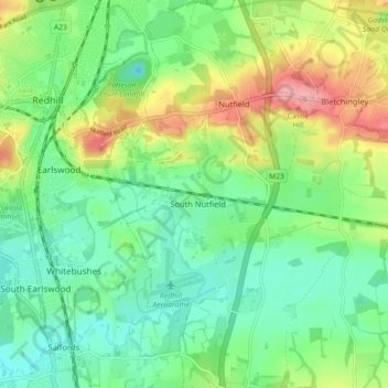
Name: Nutfield topographic map, elevation, terrain.
Location: Nutfield, Tandridge District, Surrey, England, United Kingdom (51.19901 -0.15499 51.25472 -0.10611)
Average elevation: 88 m
Minimum elevation: 47 m
Maximum elevation: 168 m
Other topographic maps
Click on a map to view its topography, its elevation and its terrain.
Caterham
United Kingdom > England > Surrey > Tandridge District
In 1840 Caterham contained a total of 477 residents (figures taken from that census, compiled in an 1848 topographical encyclopedia) and in 1848 468 acres (189 ha) of its 2,386 acres (966 ha) were common land. Similar to today, 175 acres (71 ha) mostly steeper acres were woodland.
Average elevation: 157 m