
Make a donation
Cantabrian Mountains topographic map
Click on the map to display elevation.
Make a donation
Cantabrian Mountains
The descent from the southern range to the high plateaus of Castile is more gradual, and several large rivers, notably the Ebro, rise here and flow to the south or west. The breadth of the Cantabrian chain, with all its ramifications, increases from about 97 km (60 mi) in the east to about 185 kilometres (115 mi) in the west. Many peaks are over 1,800 metres (6,000 ft) high, but the greatest altitudes are attained in the central ridges on the borders of León, Asturias, Palencia and Cantabria. Here are the highest peak Torre de Cerredo (2,648 metres (8,688 ft)), Peña Vieja (2,615 metres (8,579 ft)), Peña Prieta (2,531 metres (8,304 ft)) and Espigüete (2,407 metres (7,898 ft)); an unnamed summit in the Picos de Europa, to which range the Peña Vieja also belongs, rises on the right bank of the Sella to a height of 2,452 metres (8,045 ft); further west the peaks of Manpodres, Peña Ubiña, Peña Rubia and Cuiña all exceed 2,100 metres (7,000 ft). A conspicuous feature of the chain, as of the adjacent tableland, is the number of its parameras, isolated plateaus shut in by lofty mountains or even by precipitous walls of rock.
Make a donation
About this map
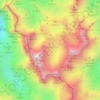
Name: Cantabrian Mountains topographic map, elevation, terrain.
Location: Cantabrian Mountains, Cabrales, Asturias, Spain (43.20000 -4.84805 43.20010 -4.84795)
Average elevation: 2,209 m
Minimum elevation: 1,733 m
Maximum elevation: 2,625 m
Make a donation
Other topographic maps
Click on a map to view its topography, its elevation and its terrain.
Make a donation