
Thank you for supporting this site ❤️
Make a donation
Make a donation
Twin Peaks topographic map
Click on the map to display elevation.
Thank you for supporting this site ❤️
Make a donation
Make a donation
About this map
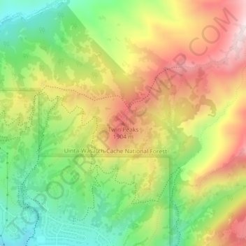
Name: Twin Peaks topographic map, elevation, terrain.
Average elevation: 1,742 m
Minimum elevation: 1,508 m
Maximum elevation: 2,003 m
Thank you for supporting this site ❤️
Make a donation
Make a donation
Other topographic maps
Click on a map to view its topography, its elevation and its terrain.
Jordan River OHV/ Modelport State Park
United States > Utah > Salt Lake County > Salt Lake City
Average elevation: 1,286 m