
Thank you for supporting this site ❤️
Make a donation
Make a donation
Thamarassery topographic map
Click on the map to display elevation.
Thank you for supporting this site ❤️
Make a donation
Make a donation
About this map
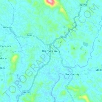
Name: Thamarassery topographic map, elevation, terrain.
Location: Thamarassery, Kozhikode district, Kerala, 673573, India (11.37775 75.89695 11.45775 75.97695)
Average elevation: 49 m
Minimum elevation: 12 m
Maximum elevation: 351 m
Thank you for supporting this site ❤️
Make a donation
Make a donation
Other topographic maps
Click on a map to view its topography, its elevation and its terrain.