
Wettstein topographic map
Interactive map
Click on the map to display elevation.
About this map
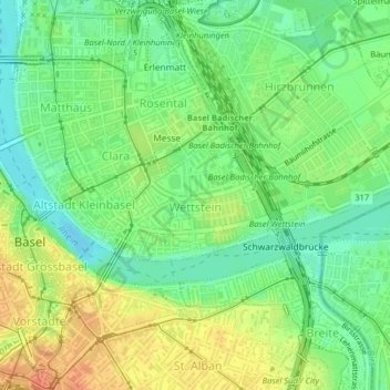
Name: Wettstein topographic map, elevation, terrain.
Location: Wettstein, Bâle, Bâle-Ville, Suisse (47.55676 7.59671 47.56586 7.61369)
Average elevation: 263 m
Minimum elevation: 243 m
Maximum elevation: 288 m
Other topographic maps
Click on a map to view its topography, its elevation and its terrain.
Hirzbrunnen
Suisse > Bâle-Ville > Bâle
Hirzbrunnen, Bâle, Bâle-Ville, 5068, Suisse
Average elevation: 260 m
St. Alban
Suisse > Bâle-Ville > Bâle
St. Alban, Bâle, Bâle-Ville, 4052, Suisse
Average elevation: 286 m