
Thank you for supporting this site ❤️
Make a donation
Make a donation
Herzliya topographic map
Click on the map to display elevation.
Thank you for supporting this site ❤️
Make a donation
Make a donation
About this map
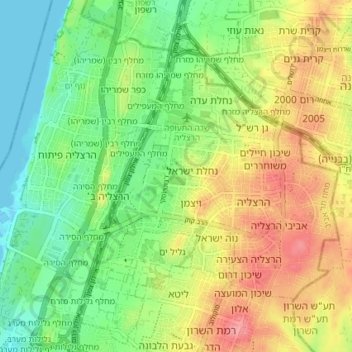
Name: Herzliya topographic map, elevation, terrain.
Location: Herzliya, Tel Aviv Subdistrict, Tel-Aviv District, Israel (32.14402 34.79155 32.19648 34.86463)
Average elevation: 38 m
Minimum elevation: -1 m
Maximum elevation: 89 m
Thank you for supporting this site ❤️
Make a donation
Make a donation