
Make a donation
West Hartford topographic map
Click on the map to display elevation.
Make a donation
About this map
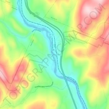
Name: West Hartford topographic map, elevation, terrain.
Average elevation: 226 m
Minimum elevation: 103 m
Maximum elevation: 377 m
Make a donation
Other topographic maps
Click on a map to view its topography, its elevation and its terrain.
South Woodstock
United States > Vermont > Windsor County > Woodstock
South Woodstock is an unincorporated village and census-designated place (CDP) in the town of Woodstock in Windsor County, Vermont, United States. Its elevation is 1,040 feet (320 m), and it is located at 43°33′56″N 72°31′56″W / 43.56556°N 72.53222°W / 43.56556; -72.53222 (43.5656256,…
Average elevation: 385 m
Make a donation
West Windsor
United States > Vermont > Windsor County
The unincorporated village of Brownsville is one of the few urban areas in the town and sits at the northwestern base of Mount Ascutney (elevation 3143 ft.).
Average elevation: 366 m
Make a donation