
Thank you for supporting this site ❤️
Make a donation
Make a donation
Corno do Boi topographic map
Click on the map to display elevation.
Thank you for supporting this site ❤️
Make a donation
Make a donation
About this map
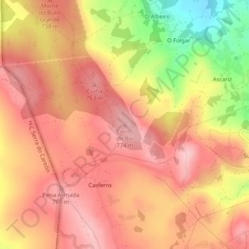
Name: Corno do Boi topographic map, elevation, terrain.
Location: Corno do Boi, Friol, Lugo, Galicia, 15140, España (42.99243 -7.89600 42.99253 -7.89590)
Average elevation: 710 m
Minimum elevation: 590 m
Maximum elevation: 770 m
Thank you for supporting this site ❤️
Make a donation
Make a donation
Other topographic maps
Click on a map to view its topography, its elevation and its terrain.
Serra do Careón
España > Galicia > Lugo > Friol
Con una altitud media de 550 metros y máxima de 798 metros, en el monte Careón. Dominan los granitos intrusivos, gneis de "ojo de sapo" y esquistos. En esta sierra nacen el río Narla, afluente del Miño, y el río Pambre, el río Seco y el río Furelos, afluentes los tres del río Ulla.
Average elevation: 730 m