
Thank you for supporting this site ❤️
Make a donation
Make a donation
Huizen topographic map
Click on the map to display elevation.
Thank you for supporting this site ❤️
Make a donation
Make a donation
Huizen
Topographic map of Huizen, March 2014.
Thank you for supporting this site ❤️
Make a donation
Make a donation
About this map
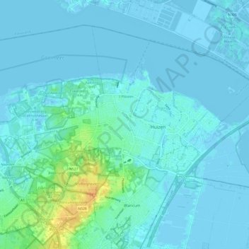
Name: Huizen topographic map, elevation, terrain.
Location: Huizen, North Holland, Netherlands (52.26712 5.18470 52.32576 5.30546)
Average elevation: 3 m
Minimum elevation: -7 m
Maximum elevation: 31 m
Thank you for supporting this site ❤️
Make a donation
Make a donation
Other topographic maps
Click on a map to view its topography, its elevation and its terrain.