
Biddlesden topographic map
Click on the map to display elevation.
About this map
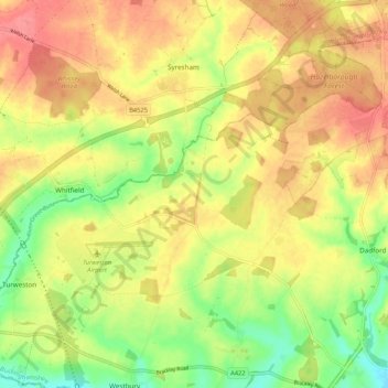
Name: Biddlesden topographic map, elevation, terrain.
Location: Biddlesden, Buckinghamshire, England, United Kingdom (52.03204 -1.11512 52.06613 -1.00886)
Average elevation: 132 m
Minimum elevation: 93 m
Maximum elevation: 163 m
Other topographic maps
Click on a map to view its topography, its elevation and its terrain.
Hotley Bottom
United Kingdom > England > Buckinghamshire > Great Missenden > Prestwood
Average elevation: 182 m
Wapsey's Wood Landfill Site
United Kingdom > England > Buckinghamshire > Beaconsfield > Jordans
Average elevation: 93 m
Doddershall Wood
United Kingdom > England > Buckinghamshire > Grendon Underwood
Average elevation: 77 m