
Make a donation
Annette Island topographic map
Click on the map to display elevation.
Make a donation
Annette Island
The lower elevations of Annette Island have a Marine west coast climate (Köppen Cfb), with windy and wet weather year-round, cool winters, and mild summers, and straddle the border between USDA Plant Hardiness Zones 7 and 8. Due to its southerly and maritime location, with an annual mean temperature of 47.7 °F (8.7 °C), the Annette Island Airport is one of the warmest locations statewide. Precipitation falls on most days during the winter, and the seasonal total snowfall of 33.5 inches (85 cm) occurs mostly from November to March, with some accumulation during April. Snowfall in May and October is relatively rare; warm spells raise the high to 50 °F (10 °C) for several days each month. During summer, there is an average of 17 days with 70 °F (21 °C)+ highs, and rain still falls on around half of the days. Precipitation averages more than 103 inches (2.62 m) annually, with June and July being the driest months and October and November the wettest. Extreme temperatures have ranged from −4 °F (−20 °C) on January 30, 1947, up to 93 °F (34 °C) on June 19, 2004, with the temperature having fallen below 0 °F (−18 °C) only on a handful of occasions. In addition, the Annette Island Airport holds the Alaska state monthly record high temperatures for January (66 °F or 19 °C on January 14, 2017), April (82 °F or 28 °C on April 29, 1976), and November (67 °F or 19 °C on November 1, 1970).
Make a donation
About this map
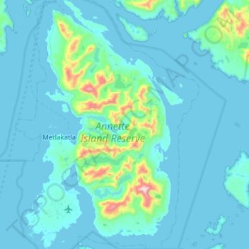
Name: Annette Island topographic map, elevation, terrain.
Average elevation: 78 m
Minimum elevation: -9 m
Maximum elevation: 1,067 m
Make a donation
Other topographic maps
Click on a map to view its topography, its elevation and its terrain.
Make a donation
Make a donation
Mount Okmok
United States > Alaska > Unorganized Borough
After a period of quiescence, an intense eruption took place at Okmok in 43 BCE. A rhyodacitic eruption column rose over the volcano from a vent in its northern part. Pumice lapilli fell out from the eruption column. The fallout was emplaced in three distinct units, with a brief break between the first two…
Average elevation: 713 m
Make a donation
Make a donation
Mount Wrangell
United States > Alaska > Unorganized Borough
Modern Mount Wrangell, built upon the remnants of a mid-Pleistocene volcano, has an eruptive history spanning from 750,000 years ago to minor phreatic eruptions in 1884. The shield volcano features an ice-filled caldera 2.5 by 3.7 miles (4 by 6 km) in diameter at the top of Wrangell's broad summit. The caldera…
Average elevation: 4,013 m
Mount Blackburn
United States > Alaska > Unorganized Borough
Mount Blackburn is a large, dramatic peak, with great local relief and independence from higher peaks. Its west face drops over 11,000 ft (3,350 m) to the Kuskulana Glacier in less than 4 horizontal miles (6.4 km). Its other faces drop 8,000–10,000 ft (2,440–3,050 m), all in less than 8 miles (13 km). The…
Average elevation: 4,530 m
Make a donation
Mount Sanford
United States > Alaska > Unorganized Borough
Mount Sanford was first climbed on July 21, 1938 by noted mountaineers Terris Moore and Bradford Washburn, via the still-standard North Ramp route up the Sheep Glacier. This route "offers little technical difficulty" and "is a glacier hike all the way to the summit" but is still a serious mountaineering…
Average elevation: 4,221 m
Make a donation
Make a donation
Make a donation
Little Diomede Island
United States > Alaska > Unorganized Borough > Diomede > Diomede
Average elevation: 160 m
Make a donation
Eagle Summit
United States > Alaska > Unorganized Borough
It was for this latter reason that engineers chose Eagle Summit as the route to build the Steese Highway, which connects Fairbanks, Alaska to the Yukon River at Circle. In 1927, just 11 years after Stuck became one of the first Americans to navigate Eagle Summit on dog sled, the highway was completed and road…
Average elevation: 1,068 m
Make a donation
Make a donation
Make a donation
Kasatochi Island
United States > Alaska > Unorganized Borough
Kasatochi Island is a member of the Aleutian Islands, which lie above a narrow ridge that separates the Bering Sea from the North Pacific. It lies at the Atka Pass northwest of the western tip of Atka Island and east of Great Sitkin Island. It is at 52.177° N latitude and 175.508° W longitude, with a summit…
Average elevation: 53 m
Make a donation
Make a donation
Make a donation
Make a donation
Make a donation
Make a donation
Make a donation