
Hameau Aloyse Merkling topographic map
Interactive map
Click on the map to display elevation.
About this map
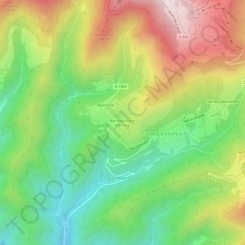
Name: Hameau Aloyse Merkling topographic map, elevation, terrain.
Average elevation: 773 m
Minimum elevation: 418 m
Maximum elevation: 1,259 m
Other topographic maps
Click on a map to view its topography, its elevation and its terrain.
Großer Belchen
Frankreich > Grand Est > Oberelsass > Goldbach-Altenbach
Großer Belchen, Goldbach-Altenbach, Thann-Gebweiler, Oberelsass, Grand Est, Metropolitanes Frankreich, 68760, Frankreich
Average elevation: 1,139 m