
Thank you for supporting this site ❤️
Make a donation
Make a donation
Eede topographic map
Click on the map to display elevation.
Thank you for supporting this site ❤️
Make a donation
Make a donation
About this map
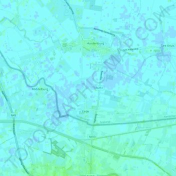
Name: Eede topographic map, elevation, terrain.
Location: Eede, Sluis, Zeeland, Netherlands (51.24149 3.41787 51.27074 3.52804)
Average elevation: 2 m
Minimum elevation: -3 m
Maximum elevation: 7 m
Thank you for supporting this site ❤️
Make a donation
Make a donation
Other topographic maps
Click on a map to view its topography, its elevation and its terrain.