
Balfour topographic map
Interactive map
Click on the map to display elevation.
About this map
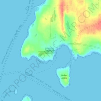
Name: Balfour topographic map, elevation, terrain.
Location: Balfour, Islas Orcadas, Escocia, KW17 2DX, Reino Unido (59.01313 -2.93180 59.05313 -2.89180)
Average elevation: 9 m
Minimum elevation: -1 m
Maximum elevation: 48 m
Other topographic maps
Click on a map to view its topography, its elevation and its terrain.
Burray
Reino Unido > Escocia > Islas Orcadas > Burray
Burray, Islas Orcadas, Escocia, Reino Unido
Average elevation: 7 m
Kirkwall
Reino Unido > Escocia > Islas Orcadas > Kirkwall
Kirkwall, Islas Orcadas, Escocia, KW15 1DH, Reino Unido
Average elevation: 27 m