
Hygna topographic map
Interactive map
Click on the map to display elevation.
About this map
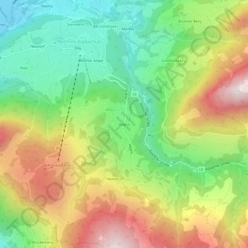
Name: Hygna topographic map, elevation, terrain.
Location: Hygna, Reith im Alpbachtal, Bezirk Kufstein, 6235, Österreich (47.38347 11.87052 47.42347 11.91052)
Average elevation: 926 m
Minimum elevation: 515 m
Maximum elevation: 1,474 m
Other topographic maps
Click on a map to view its topography, its elevation and its terrain.
Neudorf
Österreich > Reith im Alpbachtal
Neudorf, Reith im Alpbachtal, Bezirk Kufstein, 6325, Österreich
Average elevation: 692 m