
Gardon topographic map
Interactive map
Click on the map to display elevation.
About this map
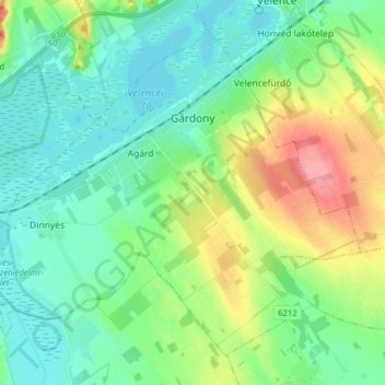
Name: Gardon topographic map, elevation, terrain.
Average elevation: 125 m
Minimum elevation: 100 m
Maximum elevation: 187 m
Other topographic maps
Click on a map to view its topography, its elevation and its terrain.
Neudörfl
Ungarn > Komitat Fejér > Neudörfl
Neudörfl, Bicskei járás, Komitat Fejér, Mitteltransdanubien, Transdanubien, Ungarn
Average elevation: 182 m
Kaltenberg
Ungarn > Komitat Fejér > Kaltenberg
Kaltenberg, Gárdonyi járás, Komitat Fejér, Mitteltransdanubien, Transdanubien, 8097, Ungarn
Average elevation: 194 m