
Thank you for supporting this site ❤️
Make a donation
Make a donation
Boswell topographic map
Click on the map to display elevation.
Thank you for supporting this site ❤️
Make a donation
Make a donation
About this map
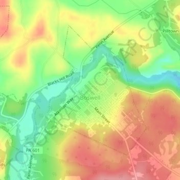
Name: Boswell topographic map, elevation, terrain.
Location: Boswell, Somerset County, Pennsylvania, United States (40.15283 -79.03774 40.17235 -79.01786)
Average elevation: 583 m
Minimum elevation: 533 m
Maximum elevation: 628 m
Thank you for supporting this site ❤️
Make a donation
Make a donation
Other topographic maps
Click on a map to view its topography, its elevation and its terrain.
Barronvale
United States > Pennsylvania > Somerset County > Middlecreek Township
Average elevation: 604 m
Tire Hill
United States > Pennsylvania > Somerset County > Conemaugh Township
Average elevation: 466 m
Thank you for supporting this site ❤️
Make a donation
Make a donation
2768 feet
United States > Pennsylvania > Somerset County > Jefferson Township
Average elevation: 811 m
Thank you for supporting this site ❤️
Make a donation
Make a donation