
Thank you for supporting this site ❤️
Make a donation
Make a donation
Pretoro topographic map
Click on the map to display elevation.
Thank you for supporting this site ❤️
Make a donation
Make a donation
About this map
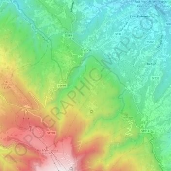
Name: Pretoro topographic map, elevation, terrain.
Location: Pretoro, Chieti, Italy (42.15975 14.09433 42.24075 14.18101)
Average elevation: 827 m
Minimum elevation: 233 m
Maximum elevation: 1,952 m
Thank you for supporting this site ❤️
Make a donation
Make a donation
Other topographic maps
Click on a map to view its topography, its elevation and its terrain.
Thank you for supporting this site ❤️
Make a donation
Make a donation
Thank you for supporting this site ❤️
Make a donation
Make a donation