
Staudamm Schiffenen topographic map
Interactive map
Click on the map to display elevation.
About this map
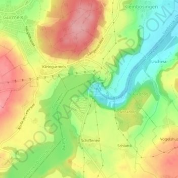
Name: Staudamm Schiffenen topographic map, elevation, terrain.
Average elevation: 550 m
Minimum elevation: 488 m
Maximum elevation: 610 m
Other topographic maps
Click on a map to view its topography, its elevation and its terrain.
Schiffenen
Suisse > Fribourg > District de la Singine > Guin > Schiffenen
Schiffenen, Guin, District de la Singine, Fribourg, 3186, Suisse
Average elevation: 567 m